Protecting endangered megafauna through AI analysis of drone images in a low-connectivity setting: a case study from Namibia
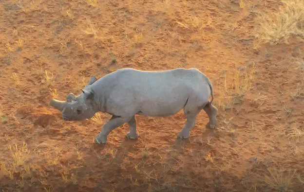 Image credit: WildTrack
Abstract
Assessing the numbers and distribution of at-risk megafauna such as the black rhino (Diceros bicornis) is key to effective conservation, yet such data are difficult to obtain. Many current monitoring technologies are invasive to the target animals and expensive. Satellite monitoring is emerging as a potential tool for very large animals (e.g., elephant) but detecting smaller species requires higher resolution imaging. Drones can deliver the required resolution and speed of monitoring, but challenges remain in delivering automated monitoring systems where internet connectivity is unreliable or absent. This study describes a model built to run on a drone to identify in situ images of megafauna. Compared with previously reported studies, this automated detection framework has a lower hardware cost and can function with a reduced internet bandwidth requirement for local network communication. It proposes the use of a Jetson Xavier NX, onboard a Parrot Anafi drone, connected to the internet throughout the flight to deliver a lightweight web-based notification system upon detection of the target species. The GPS location with the detected target species images is sent using MQ Telemetry Transport (MQTT), a lightweight messaging protocol using a publisher/subscriber architecture for IoT devices. It provides reliable message delivery when internet connection is sporadic. We used a YOLOv5l6 object detection architecture trained to identify a bounding box for one of five objects of interest in a frame of video. At an intersection over union (IoU) threshold of 0.5, our model achieved an average precision (AP) of 0.81 for black rhino (our primary target) and 0.83 for giraffe (Giraffa giraffa). The model was less successful at identifying the other smaller objects which were not our primary targets: 0.34, 0.25, and 0.42 for ostrich (Struthio camelus australis), springbok (Antidorcas marsupialis) and human respectively. We used several techniques to optimize performance and overcome the inherent challenge of small objects (animals) in the data. Although our primary focus for the development of the model was rhino, we included other species classes to emulate field conditions where many animal species are encountered, and thus reduce the false positive occurrence rate for rhino detections. To constrain model overfitting, we trained the model on a dataset with varied terrain, angle and lighting conditions and used data augmentation techniques (i.e., GANs). We used image tiling and a relatively larger (i.e., higher resolution) image input size to compensate for the difficulty faced in detecting small objects when using YOLO. In this study, we demonstrated the potential of a drone-based AI pipeline model to automate the detection of free-ranging megafauna detection in a remote setting and create alerts to a wildlife manager in a relatively poorly connected field environment.